

Executive Summary
Efficiency in logistics is not merely about finding the shortest path between two points; it is about managing the geometric complexity of hundreds of stops, varying vehicle capacities, and real-time traffic data. For the Depot Dash project, our goal was to replace a fragmented, manual dispatch process with an automated, geographically-aware pipeline.
This white paper details the technical architecture of the solution we built at GiantByte. By leveraging a Django backend, a React Native mobile interface, and a multi-stage optimization engine, we successfully reduced computational overhead and API costs while delivering high-accuracy routing. We utilized geographic clustering and the Google Maps Routes API to transform a “Traveling Salesperson Problem” (TSP) into a scalable, production-ready system.
The Geometric Challenge: Beyond the Simple Path
When a dispatcher looks at a map with fifty stops, their brain naturally groups pins into clusters. Computers, however, see fifty distinct coordinates. Without a pre-processing layer, an optimization algorithm attempts to calculate every possible permutation of paths: a problem that grows factorially.
For Depot Dash, we faced a “Vehicle Routing Problem” (VRP) where multiple vehicles needed to cover hundreds of geographically dispersed locations. Our primary technical hurdles included:
- Computational Complexity: Reducing the search space to maintain sub-second response times.
- API Economization: Minimizing calls to the Google Distance Matrix to manage operational costs.
- Real-World Constraints: Factoring in time windows, vehicle load limits, and live traffic.
The Three-Stage Optimization Pipeline
We engineered a modular pipeline that separates concerns into three distinct phases: Pre-clustering, Matrix Retrieval, and Sequence Optimization. This architecture allows us to handle thousands of data points without overwhelming the server or the budget.

Phase 1: Geographic Pre-Clustering (The K-Means Strategy)
Before sending any data to a routing solver, our Django backend performs a “spatial triage.” We use a K-Means Clustering algorithm to group stops based on their latitude and longitude coordinates.
By partitioning 500 stops into 10 distinct geographic zones (clusters), we effectively turn one massive, unsolvable problem into ten smaller, manageable ones. Each cluster is then assigned to a specific vehicle or depot. This ensures that a driver isn’t sent across the city for a single delivery while another driver is already in that neighborhood.
The Math Behind the Cluster:
We calculate the centroid of each stop group and minimize the squared Euclidean distance between points and their assigned centroid. This pre-processing step reduces the potential “matrix size” exponentially, which is critical for the next phase.
Phase 2: The Distance Matrix and API Integration
A straight line on a map is rarely the fastest route. To get accurate data, we integrated the Google Maps Routes API (Compute Route Matrix). This API returns the actual travel time and distance between multiple origins and destinations, accounting for road networks and current traffic conditions.
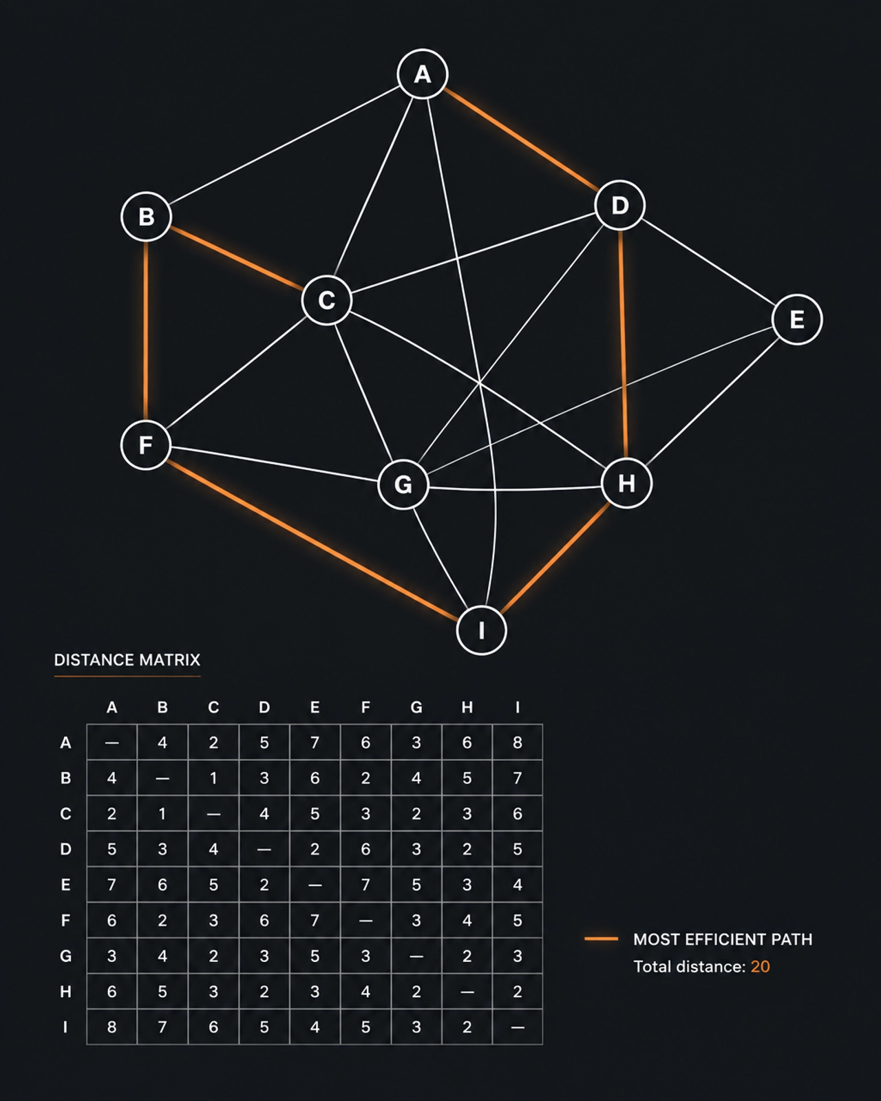
However, calling a 50×50 matrix (2,500 elements) is expensive and slow. To optimize this, our pipeline employs Radius Filtering and k-Nearest Neighbor (k-NN) pruning.
- Pruning: We only request distance data for stops that are logically reachable within a specific time window or distance radius.
- Caching: We implemented a
DistanceMatrixCachemodel in Django. If the travel time between Point A and Point B was calculated ten minutes ago, we reuse that data rather than paying for a new API call.
Phase 3: The Optimization Engine (Google OR-Tools)
Once we have a refined distance matrix for a cluster, we feed that data into Google OR-Tools, a fast and portable software suite for combinatorial optimization.
Using Python, we define the VRP parameters:
- Cost Function: We prioritize time over distance to ensure deliveries meet their “Expected Time of Arrival” (ETA).
- Capacity Constraints: We define vehicle “loads” so the solver never assigns more stops to a van than its physical volume allows.
- Time Windows: The solver respects “Hard” and “Soft” windows, ensuring premium deliveries are prioritized during their specific slots.
The output is a mathematically optimized sequence of IDs, which we then map back to our database objects.
Mobile Integration: Delivering Data to the Front Line
A routing algorithm is useless if the driver can’t follow it. We built the Depot Dash mobile interface using React Native, ensuring a seamless experience across both iOS and Android devices.
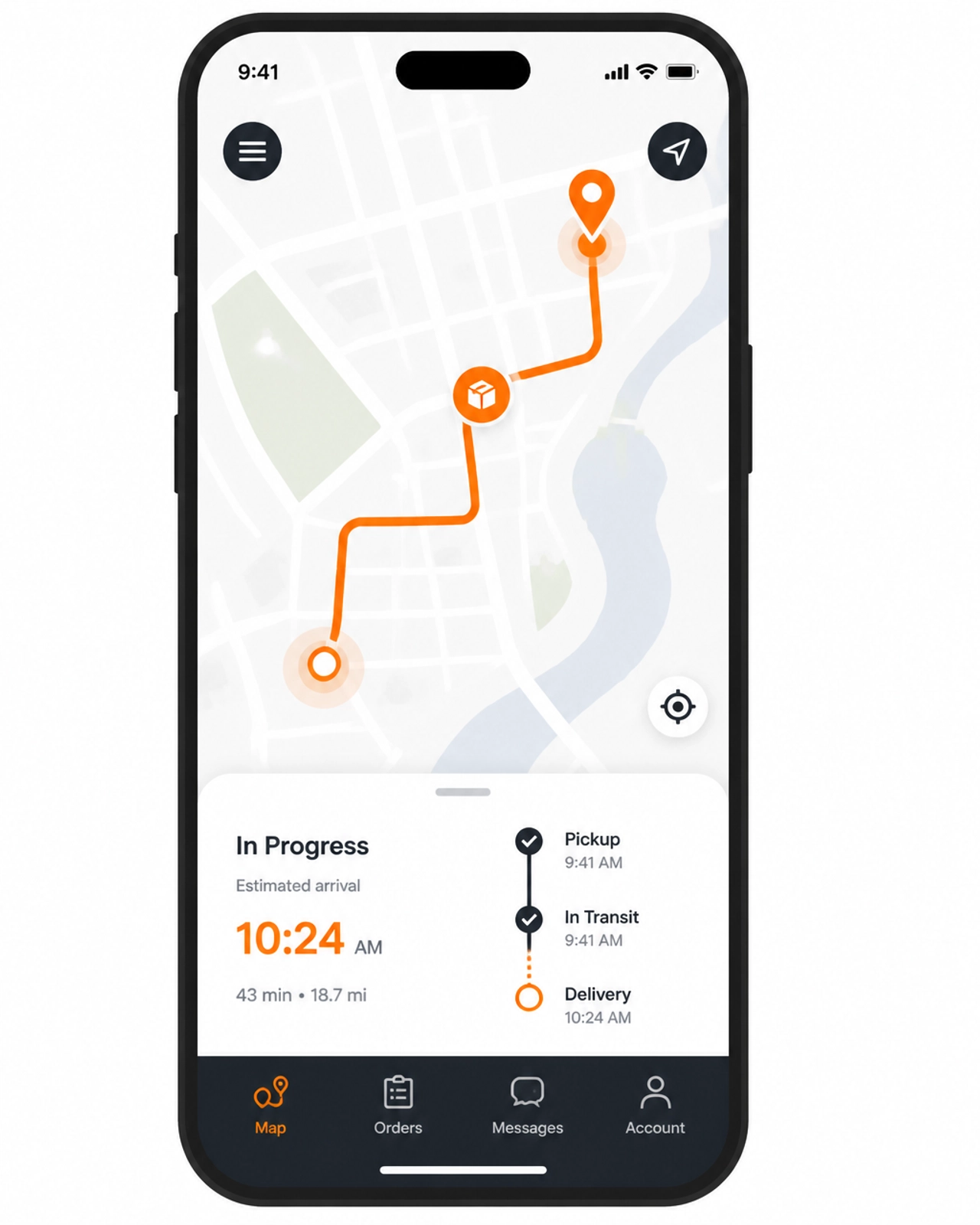
The communication flow works as follows:
- Request: The React Native app sends the driver’s current GPS coordinates to the Django API.
- Processing: The backend runs the three-stage pipeline (Clustering -> Matrix -> OR-Tools).
- Geometry: After the sequence is optimized, we make a final call to Google Compute Routes to retrieve the encoded polyline (the actual blue line on the map).
- Delivery: The app receives a JSON payload containing the optimized stop sequence and the polyline geometry for rendering.
By offloading the “heavy lifting” to the Python backend, the mobile app remains lightweight and responsive, even when handling complex, multi-stop routes.
Scalability and Infrastructure
We built the Depot Dash infrastructure to be as robust as the software itself. Our backend is containerized and deployed with high-availability configurations, ensuring that as the fleet grows, the routing engine scales with it.

The use of Django REST Framework (DRF) allows for clean, documented endpoints that the React Native app consumes. We also utilized Redis for task queuing, ensuring that the heavy computational work of route optimization doesn’t block the main web thread, keeping the user experience snappy.
Conclusion: Engineering for the Real World
At GiantByte, we don’t just build apps; we solve geographic and logical puzzles. The Depot Dash pipeline is a testament to our philosophy of choosing the right tool for the job: whether that’s K-Means clustering for spatial logic, OR-Tools for optimization, or React Native for a polished user experience.
The result is a system that doesn’t just “guess” the best way; it calculates it, prunes it, and optimizes it until every kilometer and every minute is accounted for.
Interested in how this looks in practice?
Check out our accompanying case study: Depot Dash: Eliminating Logistic Lag to see the real-world impact this engineering had on delivery times and operational costs.